The newest version of SAGE III/ISS science data products are now publicly available at the NASA Atmospheric Science Data Center (ASDC). This new version (v5.3) replaces the previous version (5.2) and is the version for forward processing, but prior versions will still be available from ASDC. Several improvements are realized in v5.3. The most notable changes for the solar products are adjustments to the automated Quality Assurance (auto-QA) filtering of events and corrections for mechanical disturbances. An important upgrade for all products was choosing a slightly different representation of the ancillary meteorological fields available from the Modern-Era Retrospective analysis for Research and Applications, Version 2 (MERRA-2).
For v5.3, the auto-QA has been adjusted to recover events around the Hunga Tonga eruption that were withheld by auto-QA in v5.2. These events were being filtered out by a step in the auto-QA where Chappuis ozone products “AO3” and “MLR” were compared and flagged if they differ around the ozone maximum greater than a certain threshold. These 64 events were reviewed, deemed to be releasable, the auto-QA threshold was disabled, and the events are available in v5.3.
The nature of the occultation technique used by the SAGE series of instruments requires accurate and precise pointing knowledge. On a spacecraft with a relatively benign mechanical vibration environment, like SAGE II experienced on the Earth Radiation Budget Satellite, the developed methodology performs superbly, allowing the retrieval of precise ozone profiles from SAGE II observations. However, operating on the ISS poses challenges, as it is frequently visited by vehicles, performs maneuvers, and experiences other mechanical disturbances that affect the pointing of the instrument during measurements. A Disturbance Monitoring Package (DMP) comprised of a miniature inertial measurement unit built by Honeywell Aerospace that measures rotation in inertial space using ring laser gyroscopes oriented about three orthogonal axes is used to improve the pointing knowledge. With v5.3, data from the DMP have been incorporated into the science processing algorithm to correct pointing errors caused by these mechanical disturbances. The DMP correction has been determined to improve pointing accuracy in general and is applied to all observations unless DMP data are unavailable, and a DMP usage flag notifies users. DMP flags are included in the product files to indicate disturbances where pointing errors prior to correction exceeded mission requirements. Based on DMP data, major disturbances occur less than 10% of the time and are now corrected in v5.3. The DMP corrections are only applied to the solar products and are not implemented for lunar products at this time. Figure 1 illustrates the improvement in the uncertainty of the transmission (Level 1b) when the DMP corrections are utilized.
For both lunar and solar products v5.3 processing uses 72-layer MERRA-2 data as opposed to the 42 level MERRA-2 data used in previous versions. Generally, this extends the MERRA-2 data to higher altitudes and has finer vertical resolution in the lower stratosphere and a better fit for SAGE observations. This change to the meteorological data created no significant differences below the mesosphere.
Collectively the modifications in v5.3 result in a much more consistent SAGE dataset. Figure 2 depicts the tropical time series of aerosol extinction coefficient using v5.3 with annotations of volcanic eruptions and extreme wildfires punctuating the record.
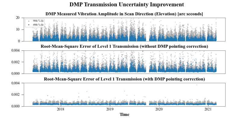
Figure 1: Event by event statistics representing improvements in computed atmospheric transmission. Top panel: DMP computed deviations in the direction of the elevation scan mirror (arc-s) for 68th and 90th percentiles. Middle-panel: Derived transmission root mean square error without using DMP elevation deviations for a representative tangent altitude. Bottom-panel: Derived transmission root mean square error with using DMP elevation deviations to correct the pointing, producing a more consistent data set. Slide 10 of Hill et al. (2022).
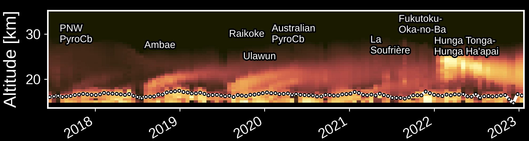
Figure 2: Version 5.3 tropical aerosol extinction coefficient. SAGE III/ISS vertically resolved aerosol extinction coefficient for the tropics over the current mission duration. Brighter colors denote larger extinction values. Also plotted as circles are the daily average tropopause altitudes showing the invisible boundary between the troposphere below and the stratosphere above. Significant volcanic eruptions and extreme wildfires that have made a resulting mark on the stratosphere are annotated.
Data Access Methods:
For questions regarding data usage, please ask us on the Earthdata Forum.
Related URLS: https://asdc.larc.nasa.gov/project/SAGE III-ISS