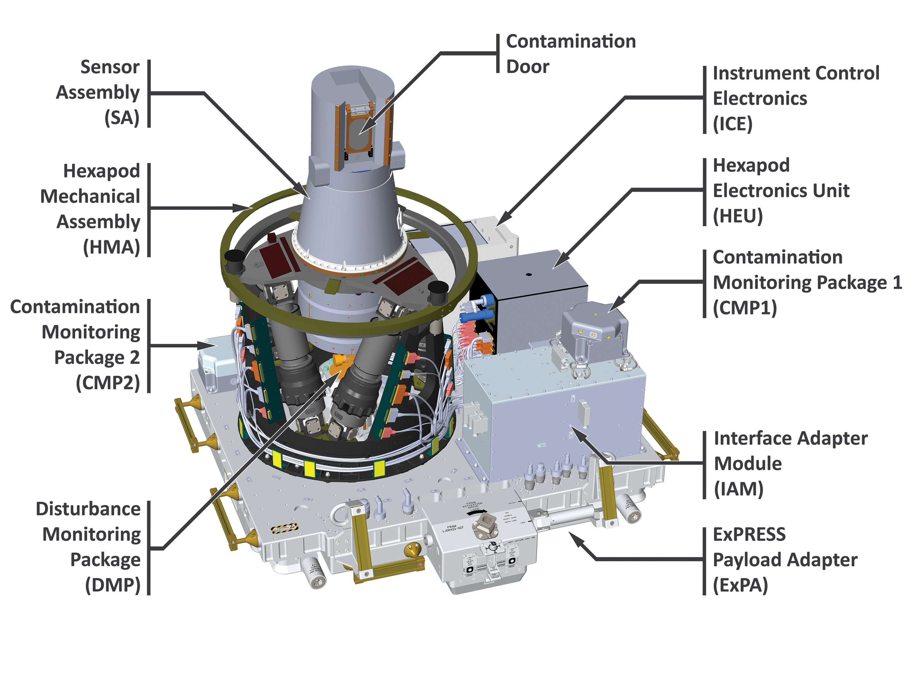
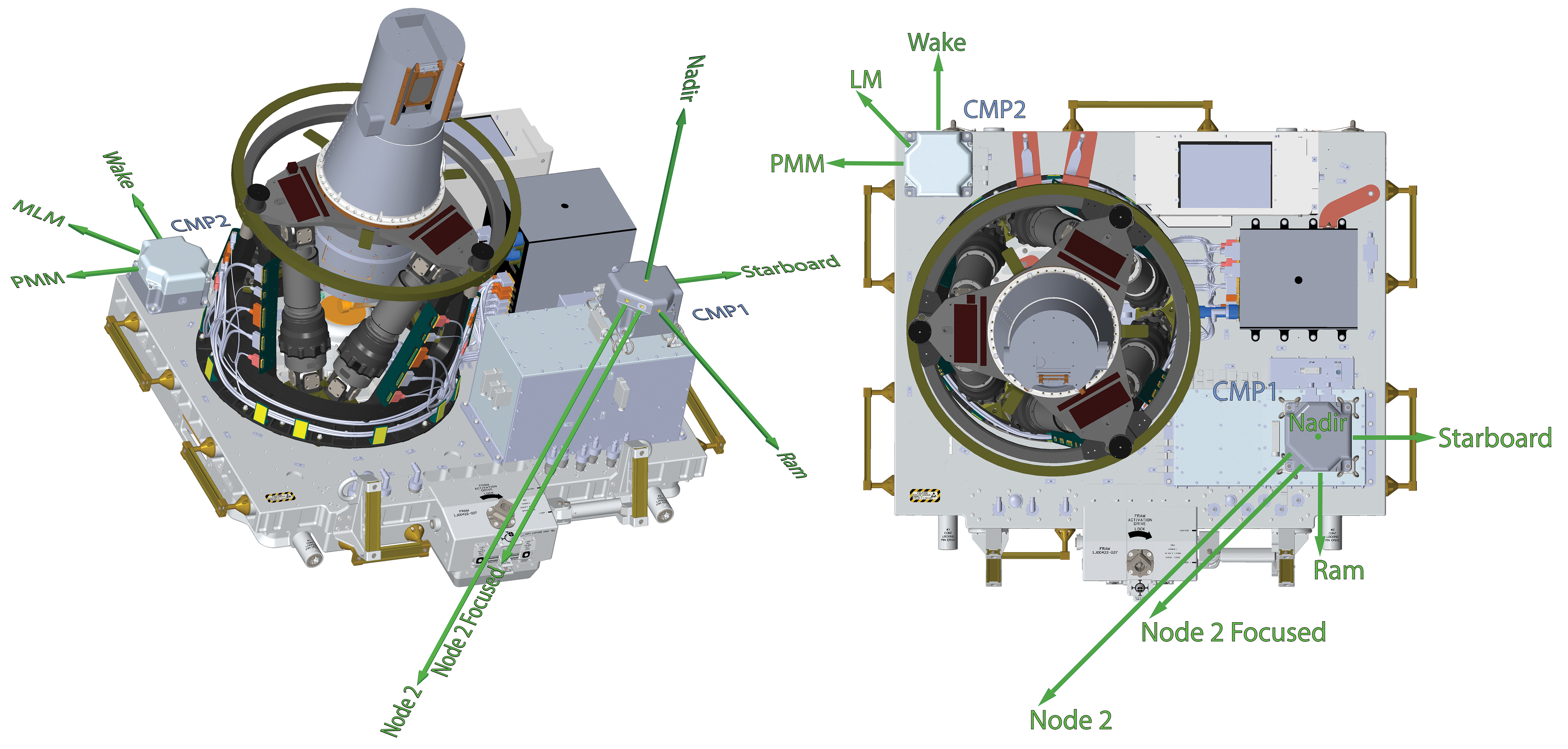
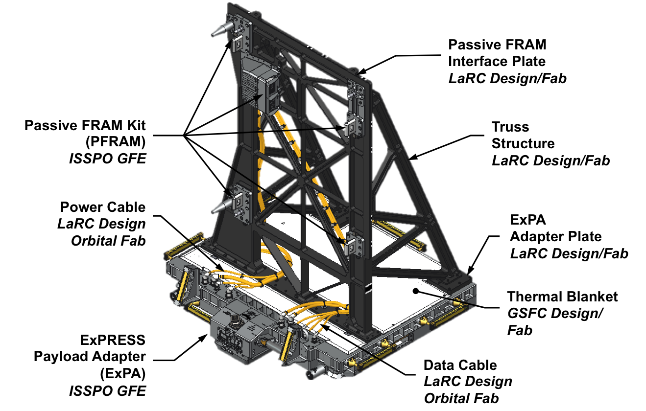
Spatial / Temporal Coverage
- Spatial Coverage: 70N to 70S
- Spatial Resolution: .5km vertical
- Temporal Coverage: 03/17/2017 – Present
- Temporal Resolution: 1 file per event
Data Products
- Ozone (solar and lunar)
- Aerosol Extinction Profiles
- Water Vapor
- Nitrogen Dioxide (solar and lunar)
- Nitrogen Trioxide (lunar)
Science Data Processing
The Level 1 and 2 science products are derived from the Level 0 data by algorithms running in the SAGE III/ISS Science Computing Facility (SCF) located at NASA Langley Research Center (LaRC). External ancillary data sources needed to proceed with Level 1 and 2 processing are: observation time/location and pressure/temperature profiles of the neutral atmosphere. GPS time and ISS position/velocity are standard products provided by ISS and are incorporated into the nominal SAGE III/ISS payload data stream. At the advice of the pre-flight ROSES selected Science Utilization Team, the Modern-Era Retrospective analysis for Research and Applications, Version 2 (MERRA-2) is used for temperature/pressure profiles of the neutral atmosphere. This is the same ancillary source used in creating the SAGE II V7 record. MERRA-2 is generally available three weeks after the end of the preceding month. Once the necessary ancillary information is available, processing a month of occultations is complete within a day or so.
The mission team reviews the results to assess the overall quality and remove any obvious failures, which are rare, not flagged by automated checks of data consistency, or stressing cases that are used for product improvement. Cleared data are then posted to the LaRC Distributed Active Archive Center (DAAC) for public distribution. These steps are usually completed within the required 10 days from receipt of the necessary inputs.
The SAGE III/ISS SCF processing system architecture consists of four Linux-based servers which support development, testing, production, and analysis of Level 1 and 2 data products. These servers have been verified to produce identical results such that they supply redundant capability to perform standard processing on a monthly cadence.
The Stratospheric Aerosol and Gas Experiment III installed on the International Space Station (SAGE III/ISS) mission team announces newly versioned science products. This SAGE III/ISS Version 6.0 (v6.0) includes Solar Level 1B, Solar Level 2, and Lunar Level 2 data products.
Vertical profiles of ozone (O3), nitrogen dioxide (NO2), and water vapor (H2O) concentrations, as well as multi-wavelength aerosol extinction coefficient and derived aerosol products, are included in the solar Level 2 data product files. Three ozone profiles are available in this release of the solar products: a UV-based mesospheric product (i.e., “o3_mes” in the product files) and two Chappuis-based products. One Chappuis-based product uses a spectrally focused spectral fitting retrieval (i.e., “o3_mlr”) while the other uses a broad-spectrum retrieval scheme that is similar to that of SAGE II (i.e., “o3_ao3”). Vertical profiles of ozone, nitrogen dioxide, and nitrogen trioxide (NO3) concentrations are included in the lunar Level 2 product files. Chlorine Dioxide (OClO) from lunar occultation are not included in this release.
Details of v6.0 can be found in the Release Notes and the Data Products User’s Guide. Pay special attention to these documents as the contents have changed from past versions for all three types of scientific data formats containing SAGE III/ISS data.
V6.0 includes algorithmic improvements, updated ancillary inputs, and the convergence of data products previously available only in separate files/outlets. Traditional SAGE products now are packaged with the newly developed derived products aerosol/cloud flag and particle size distribution parameters.
Observations cover June 2017 through the present. Until further notice, all forward processing of SAGE III/ISS will be under v6.0, which is the suggested version, but prior legacy versions are available on request from the Atmospheric Science Data Center (ASDC).
Information about this new data product, including data availability, user documentation and quality statements, relevant links, and tools for working with the data can be found at the following ASDC project page: https://asdc.larc.nasa.gov/project/SAGE%20III-ISS
The mission will continue to provide plots of the scientific products on the browse portal for superior quality data (https://sage.nasa.gov/sageiii-iss/browse_images/quicklook/) and expedited (https://sage.nasa.gov/sageiii-iss/browse_images/expedited/).
Read more about SAGE III data:
SAGE III/ISS First Atmospheric Data Release
SAGE III/ISS Lunar Data Release
SAGE III/ISS Observes 2017 British Columbia Wildfires
SAGE III Instrument Observes Aerosol Spike from Australian Fires
SAGE III Sees California Wildfire Effects in Stratosphere
Studying Earth’s Stratospheric Water Vapor
Enhanced Stratospheric Aerosols from Fukutoku-Okanoba Eruption
SAGE III Instrument Detects Stratospheric Effects of Indonesian Volcanic Eruption
SAGE III Sees Tonga Aerosols, Water Vapor Months After Eruption